Introduction:
When you think of ghost towns, what kinds of places come to mind? Pripyat? Picher, Oklahoma? Gold mining towns in California? How about Kansas? Because Kansas has many ghost towns all over the state, with most of them being in the western half. If you looked at my webmap, you would notice how many towns west of Wichita and Salina are so small, except for Garden City and Dodge City. The western half of Kansas is not as populated as the eastern half of the state, and many ghost towns and near ghost towns are out there. In this project, I'm going to use some data that I was given to complete an assignment in one of my classes to map out the decline in population in counties in Western Kansas and observe trends. We want to answer questions like these:
- Which counties in Western Kansas have shrunken the fastest?
- Have any counties in Western Kansas increased in population?
- When did most counties in Western Kansas begin shrinking in population?
- How has the construction of the Interstate affected the population of Western Kansas?
Methodology:
In this project, I will be using the R computer language to manipulate the data that I am working with. The data I am using in this project was given to me as part of my assignments in GEOG 602 at Kansas State University. The data can be downloaded by clicking this link. I will also have to explain what I mean by Western Kansas before we get too far ahead into this assignment. In other words, I have to show what the study region of this project is. Here's a quick and dirty map I whipped up in ArcGIS.
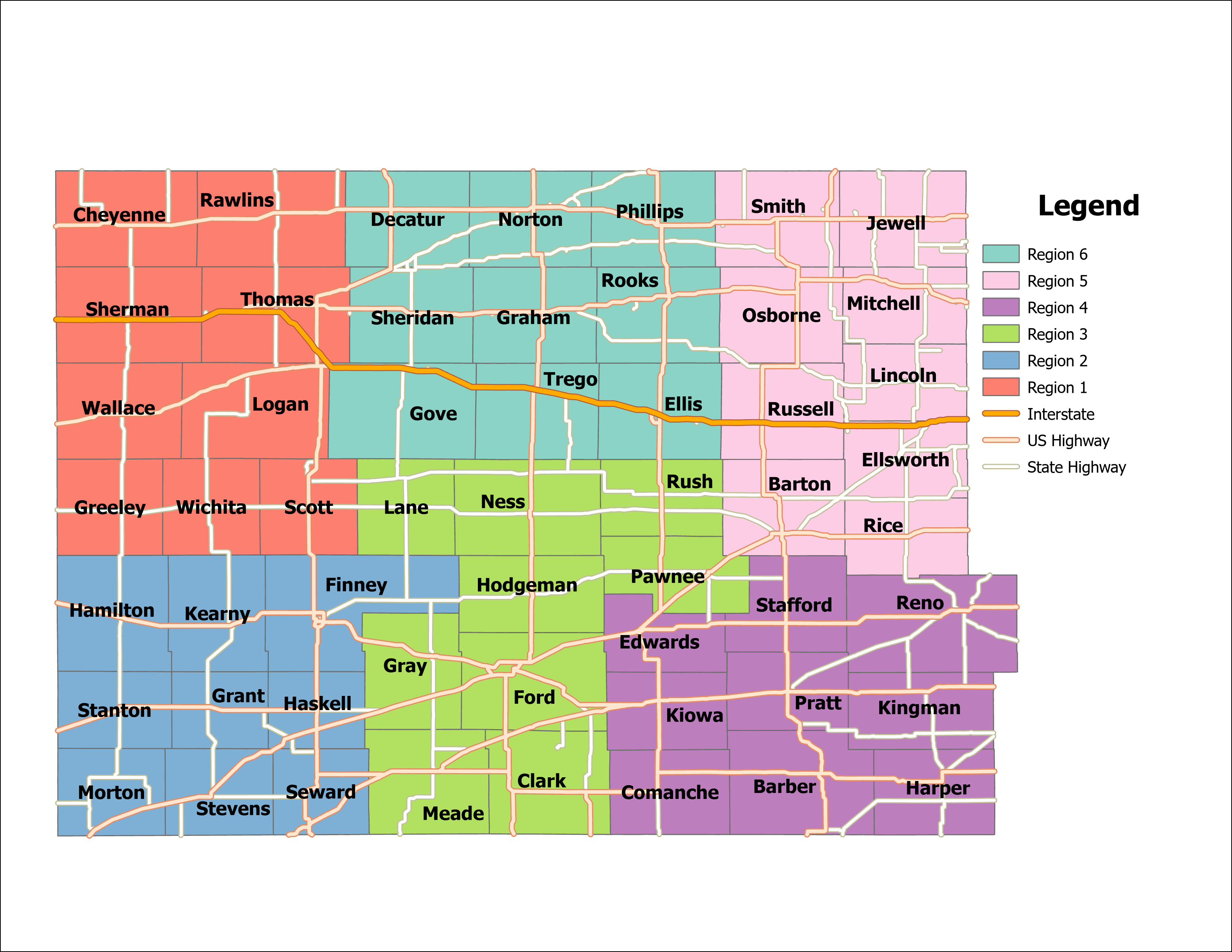
I split up the study region into six smaller subregions of nine counties. This will come in handy when I am trying to plot everything onto a small multiples chart. There will be one for each region. The major communities of this part of Kansas include Hutchinson, Hays, Dodge City, Garden City, Colby, Pratt, Great Bend, Liberal, and Goodland. Just from looking at the map, the study region takes up over half of Kansas in area, but is smaller in population than the eastern part of the state. The only interstate that runs through this region is Interstate 70. All but one major highway in this part of the country is part of the US Numbered Highway System or the state highways belonging to the Kansas Department of Transportation. Some of the more prominent highways in this region besides I-70 include US-24, US-36, US-40 (most of which has been incorporated into I-70), US-50, US-54, US-56, US-83, US-183, US-283, and US-281.
Cleaning Up the Data
We will be studying census data from 1890 on a decennial basis up until 2010. One important caveat: in 1890, there was a county that doesn't exist anymore today. Garfield County, Kansas was once its own separate county, but would merge with Finney County by the 1900 Census. On the map drawn above, Garfield County was the little orange part sticking out sandwiched between Gray and Lane Counties. Because of this, I am going to add the population of Garfield County in 1890 to the population of Finney County. This would make the population of Finney County in 4,231 in the year 1890. Don't worry about it though. Using some Excel VBA code and a couple of tricks, I was able to create a CSV file that ggplot would have an easier time handling. If you want the data for youself, click here. Now, let's get started on the project. First, I have to split up the big dataset into six smaller ones so we can analyze them individually. These represent the six regions I split the study area into, which contain nine counties each. Here's the code I used to create the regions.
> countypop <- read.csv(file="ksdepopulationdata.csv", header=TRUE, sep=",")
> region1 <- countypop[which(countypop$Region==1),]
> region2 <- countypop[which(countypop$Region==2),]
> region3 <- countypop[which(countypop$Region==3),]
> region4 <- countypop[which(countypop$Region==4),]
> region5 <- countypop[which(countypop$Region==5),]
> region6 <- countypop[which(countypop$Region==6),]
Creating Graphs:
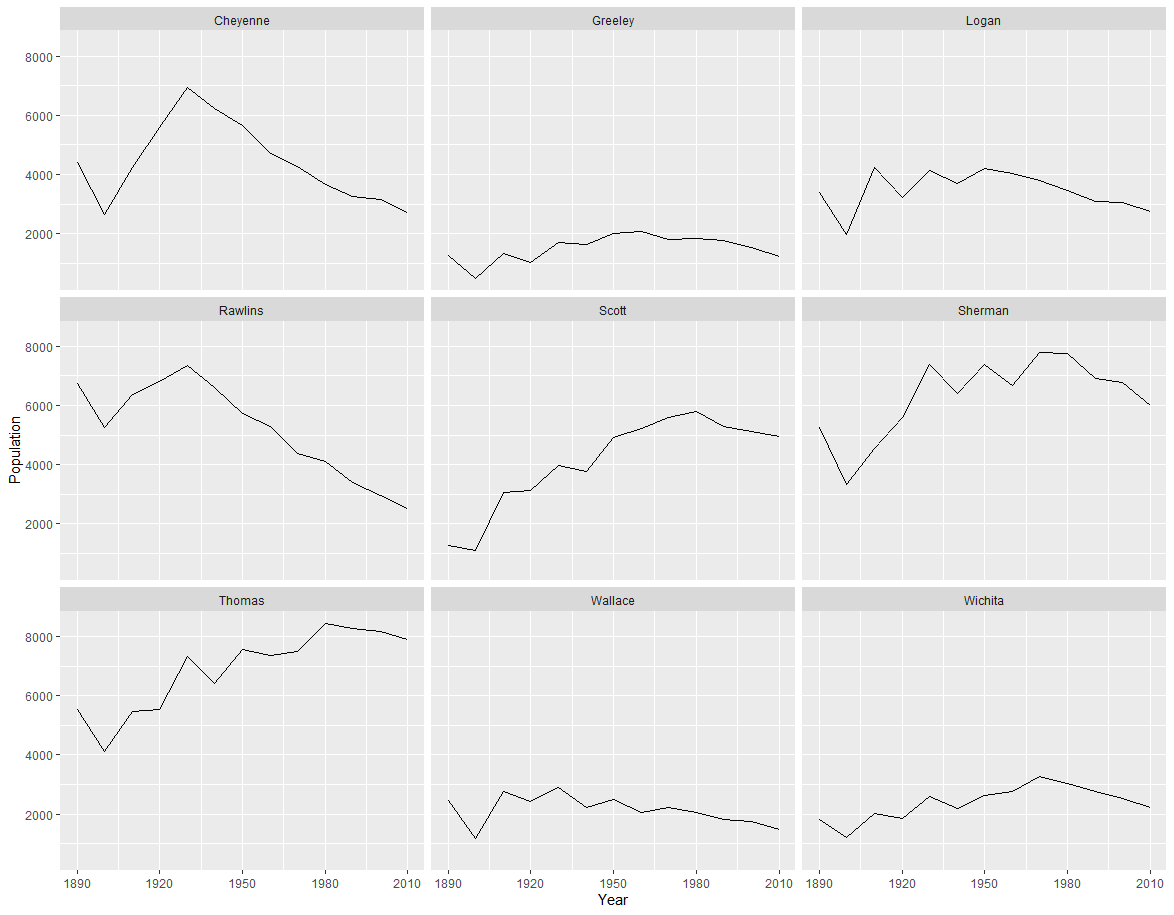
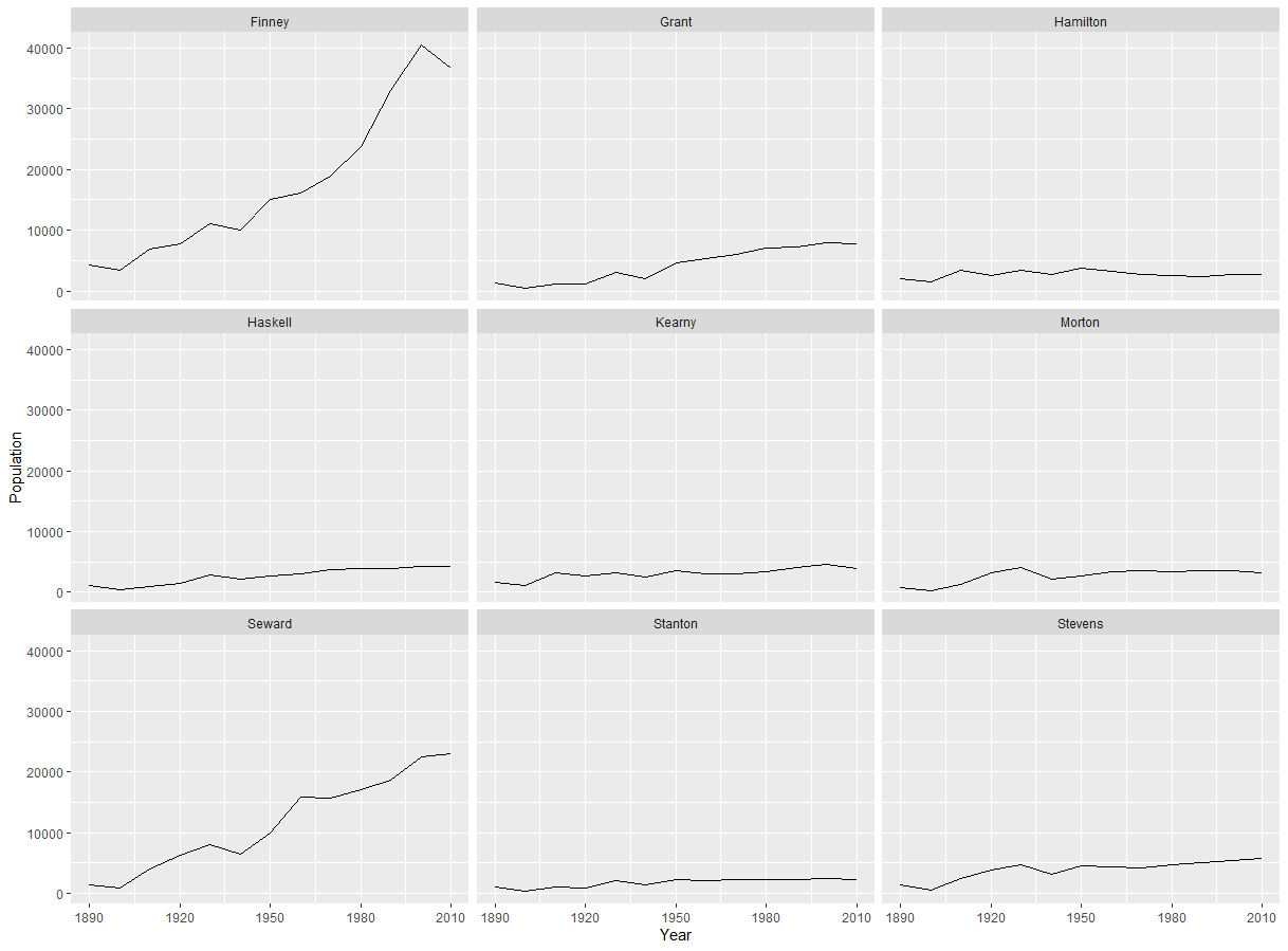
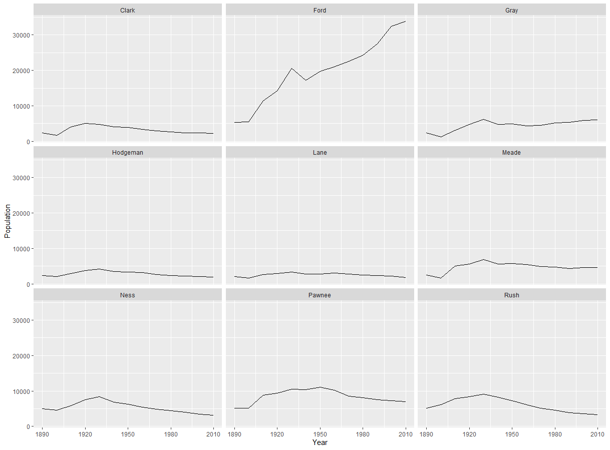
What we're going to do for this project is to create what's called a small multiple graph, where you can have many graphs packed into one image. Each region has nine counties to them, so we're going to be creating six small multiple charts with nine charts inside each of them. But we need the ggplot2 package in order to do this. If you don't have it already, simply type install.packages("ggplot2") onto your console. Also remember to pick a CRAN mirror closest to you if you are asked to do it. Here's the code I used to create each graph:
> library(ggplot2)
> ggplot(data = region1, aes(x=Year, y=Population)) + geom_line() + facet_wrap(~County)
> ggplot(data = region2, aes(x=Year, y=Population)) + geom_line() + facet_wrap(~County)
> ggplot(data = region3, aes(x=Year, y=Population)) + geom_line() + facet_wrap(~County)
> ggplot(data = region4, aes(x=Year, y=Population)) + geom_line() + facet_wrap(~County)
> ggplot(data = region5, aes(x=Year, y=Population)) + geom_line() + facet_wrap(~County)
> ggplot(data = region6, aes(x=Year, y=Population)) + geom_line() + facet_wrap(~County)
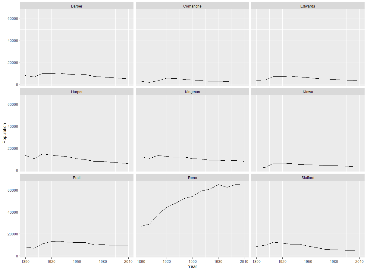
Region 1:
Region 2:
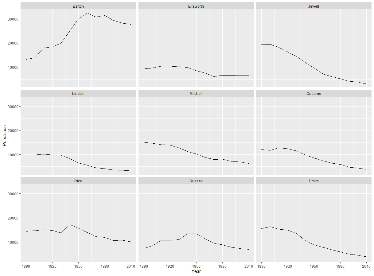
Region 3:
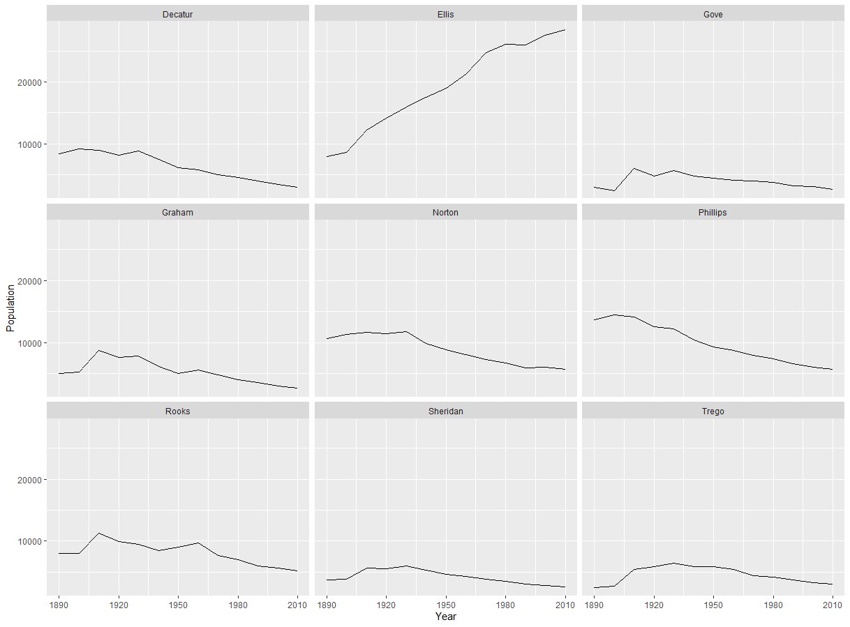
Region 4:
Region 5:
Region 6:
Analysis:
The data from these charts reveal that there are three main inflection points of population in the 20th century. The first was in 1930, which coincides with the Dust Bowl, a disaster that still scars Kansas to this day. Hundreds of people fled Kansas for greener pastures out further west, as people were convinced the state was going to become an uninhabitable wasteland, and that its resources had all been used up. Many counties had a drop in population from 1930 to 1940, especially the ones further west. Multiple counties in Regions 1, 3, and 6 experienced a consistent decline in population following the 1930 Census. This is most visible in Cheyenne and Rawlins, but is also visible in Ness, Hodgeman, Rush, Decatur, Graham, and Phillips Counties. The second major inflection point is 1950, coinciding with the Baby Boom. Advances in technology following World War II allowed for even more efficient and mechanized farming. Some farms hit it big, and became even stronger and richer than ever. But these were mostly factory farms. Ordinary family farms that gave life and jobs to numerous communities in the study region failed, dealing a devastating economic blow to these areas. If you go out to western Kansas, you'll find lots of abandoned farm houses that were sold in the 1950s, and nobody ever bought them, because they would have to be used for farming, and the local farms couldn't compete with the prices of the factory farms and big farms. Cheyenne and Rawlins Counties began declining following the Dust Bowl, and family farms getting put out of business only hastened their decline. Pawnee, Russell, and Trego Counties weathered the Dust Bowl, but began their long decline in population following the mechanization of farming after World War II. The third inflection point is 1970 with the completion of Interstate 70. Out of the 54 counties studied in this project, I-70 only passes through eight of them. After the Dust Bowl and family farms getting put out of business, communities had the chance to rebrand themselves as tourist destinations. But when I-70 was completed, people would often drive right past these towns at 70 to 80 mph, and never even notice they were there. In fact, I-70 completely bypasses Regions 2, 3, and 4 in this study. Many counties in Regions 5 and 6 are also completely bypassed. Rooks County is one county that was bypassed by I-70, and has been consistently declining in population since 1970. The counties where I-70 does pass through have remained somewhat steady in population. Examples include Thomas and Sherman Counties, which contain important economic hubs like Colby, Oakley, and Goodland. But these charts do not tell the complete story. I also created a choropleth of which census year had the highest population for each county in ArcGIS. Here it is below:
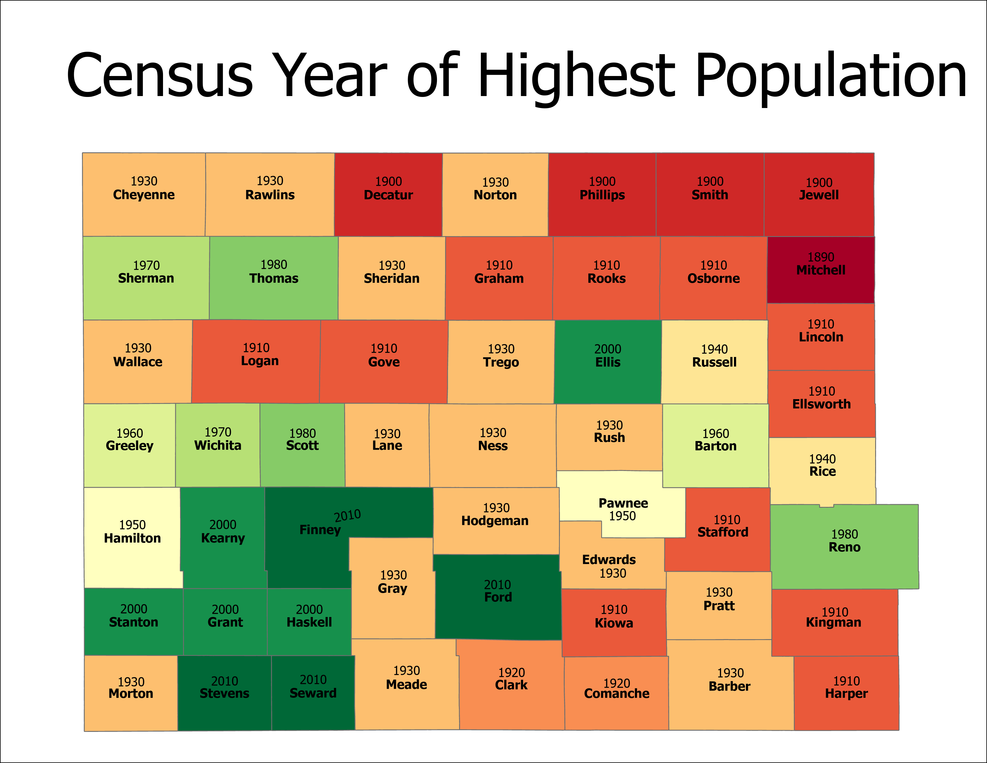
Based on this choropleth, a fourth major inflection point is revealed: 1910. This coincides with Ford revolutionizing the automobile industry with the Model T, and making cars accessible to the masses. The Model T was first released in 1908, and was in production until 1927. Suddenly, the train was completely supplanted as the main method of transportation for people. Railroad traffic dropped considerably after this, as trains were reduced to their main purpose being freight only. At the same time, the construction of railroads was continuing well into the 1910s, but now they were for freight instead of people. Small towns and villages on the plains would see their death warrant signed in being bypassed by the railroad. There are many communities all over the study region that sprung up during the days of the Old West that went under following 1910. Not only were these communities bypassed by the railroads being constructed, their importance was diminished after traffic from the Santa Fe, Oregon, and California trails began to die down. Today, nature has completely reclaimed those areas, and nothing is left of those towns but some foundations and buried objects. It's also worth noting that based on this choropleth, Mitchell County has been in decline since the beginning of the timeframe we're studying. It's also worth noting that Ford, Seward, Stevens, and Finney Counties have overall grown from 1890 to 2010.
You might be wondering, how is this possible? You'd think that because Interstate 70 goes nowhere near these counties and that these were the hardest hit parts of Kansas from the Dust Bowl that nobody would live here anymore. Well, this isn't quite the case. These factors have not deterred residents of this area from giving up hope, and attracts new residents as we speak. Almost all of the counties in Region 2 have seen a peak in population in either 2000 or 2010, and have overall grown in 100 years. This is because southwest Kansas is home to oil and gas fields, which provide jobs and money for these areas. Communities like Hugoton, Garden City, and Liberal have benefitted from the petroleum industry. Here are some choropleths I created in ArcGIS about the production of oil and gas:
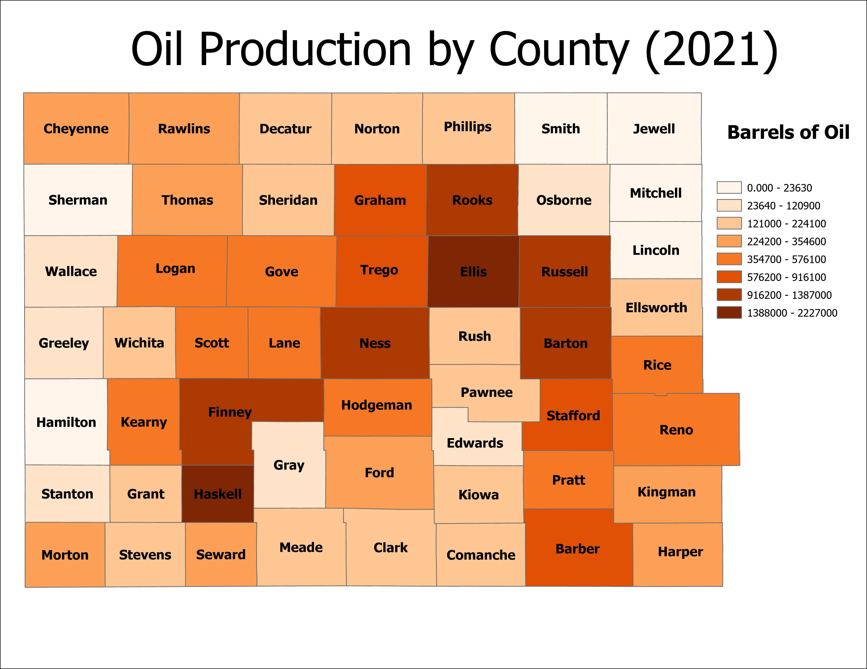
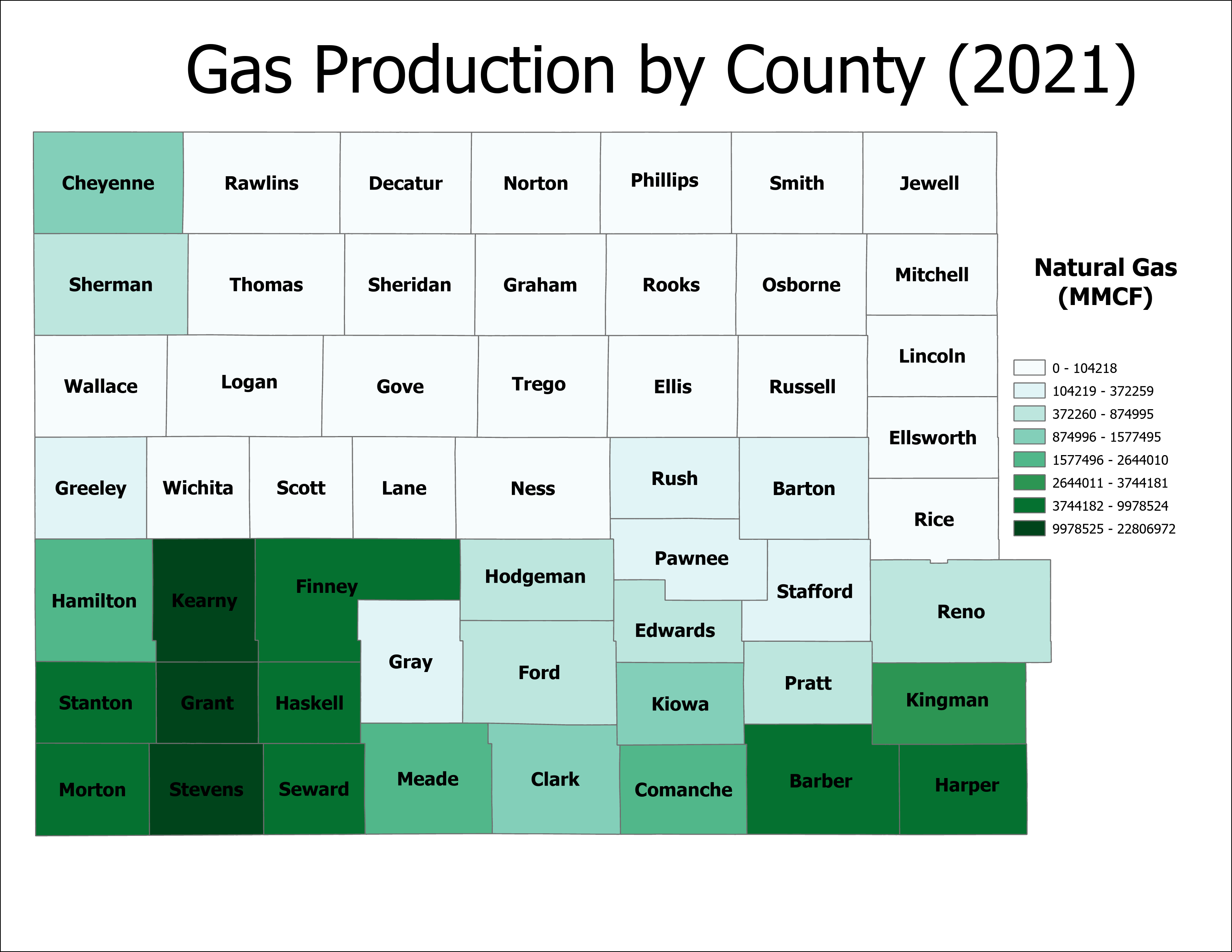
Based on these charts, Haskell and Finney Counties have been the most active overall in the production of fossil fuels. Region 2 of our study area leads the way in fossil fuel production, which results in jobs and reasons for people who live in these communities to stay, even though the factory farms have put the family farms out of business decades ago, and the Interstate goes nowhere near these counties. Mitchell, Smith, Lincoln, and Jewell Counties played an almost nonexistent contribution to this industry, which probably explains why their peak in population was 100+ years ago. But there's something else that is important to note. Look at the choropleth I made earlier about the year of maximum population. Even though Ness, Rooks, and Russell Counties are leaders in the production of oil, they have been in decline for decades. This can be explained by another map I created in ArcGIS about railroads. Click here to download the shapefiles that I used to create this map. As I mentioned before, when factory farms put family farms out of business, railroad depots all over Kansas closed in the 1950s and 1960s since railroad traffic became even more concentrated than it already was due to cars replacing trains for transportation of people. This resulted in entire railroad lines closing down, which severed numerous communities of an economic lifeline. If I-70 never passed through them, the economic fate of these communities were even further sealed. Here's the map of major railroads in Kansas that are either still active or abandoned:
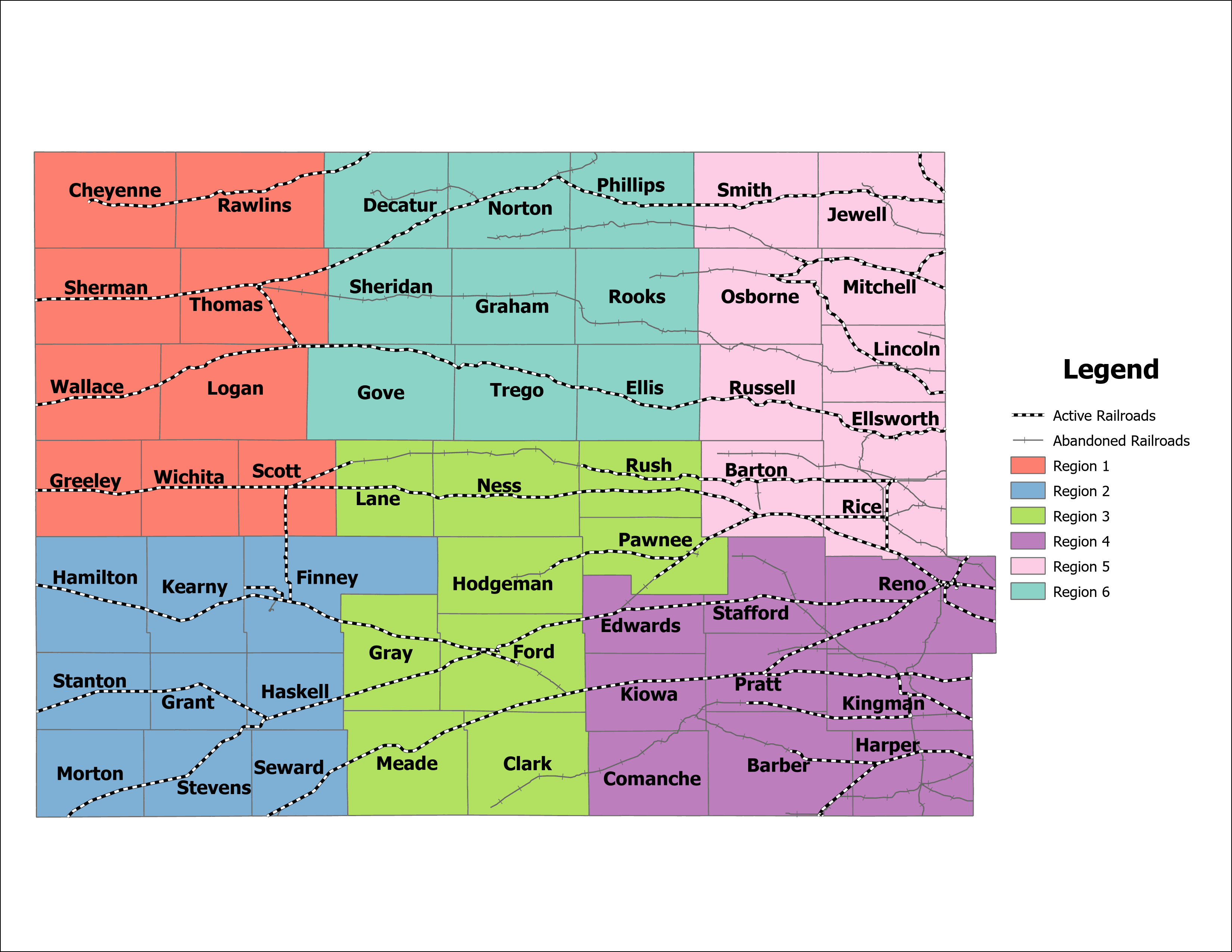
Based on this map, railroads are also the reason that Region 2 has seen overall stability and even growth in population. Communities like Garden City serve as important railroad hubs in this part of Kansas to have petroleum, crops, and other goods transported through this area. Having railyards here creates jobs and gives people a reason to stay or even move to this part of the country. The Cimarron Valley Railroad runs through Region 2, headquartered in Satanta. Regions 4, 5, and 6 are not as fortunate with railroads, with many major lines in these counties being closed. No active major rail lines pass through Rooks, Graham, or Comanche Counties, and for many counties, only one major rail line passes through them. That's not to say that no railroads pass through these counties, but they are likely to be smaller, more localized railroads with less traffic going through them. In some counties, only a small portion is covered with a major rail line, such as Clark and Hodgeman Counties. All in all, rail traffic has diminished greatly in Regions 4, 5, and 6, and the rail traffic that does pass through these areas have also become even more concentrated. This is the result of the factory farms putting the family farms out of business and numerous depots closing after World War 2. Even though some counties in Region 5 and 6 are active in the production of petroleum, there is either only one major railroad that provides transport for the product, or smaller, localized railroads for transportation, which negates any economic growth that could have occurred in these counties due to the consolidation of farms.
Two counties, though, have the opposite kind of relationship between petroleum and railroads: Ford and Reno Counties. Neither counties are top producers of petroleum, but railroad traffic is much heavier in these two counties. How are these counties not been declining in population for decades? One answer is tourism. Ford County is home to Dodge City, a mecca for fans of the Wild West. Many legendary figures in the Wild West either spent time, lived in, or frequented Dodge City such as Wyatt Earp, Doc Holliday, and Bat Masterson. Gunsmoke, the long running and popular television series about the Wild West also took place in Dodge City, a demonstration of the era's enduring history in the town. Anybody who is an avid fan of the Wild West views Dodge City as a holy city, which creates a thriving tourism industry in this city. People will come here to visit, even though the Interstate goes nowhere near it. Reno County is another example of a county in our study region that has seen overall growth since 1890, even though it has been tapering off since 1980. Its county seat and largest city is Hutchinson, which has a tourism industry of its own, though it has a bit more variety than what Dodge City has to offer. Hutchinson is also the largest city in this study region with a population of close to 40,000 as of 2020. Hutchinson is home to the Cosmosphere, a museum dedicated to the Space Race, and features the largest collection of Soviet-era spaceflight artifacts outside of Russia. The town is also home to one of the largest deposits of salt in the world, and therefore, a vast salt mine. The mines are not only used to mine salt for agricultural and business purposes, but also to preserve artifacts in the low moisture environment. Props, posters, costumes, and film negatives from movies dating back to the 1930s are stored here. The original film negatives of Gone With the Wind, Star Wars, and Ben Hur are stored here. The artifacts are in a museum that's open to the public and movie buffs alike. Hutchinson is also home to the Kansas State Fair, and the National Junior College Athletic Association (NJCAA) basketball tournament, providing even more tourism revenue to the city. The town is also an important rail hub thanks to the salt mines, one of the largest grain elevators in the world being here (clocking in at nearly half a mile long!), and even a strong manufacturing industry. Hutchinson is home to the headquarters of Collins Industries, a company that manufactures school buses, as well as manufacturing plants for StraightLine HDD, Kuhn-Krause, Siemens, and the Eaton Corporation. The town is also home to Dillon's, one of the leading grocery store chains in all of Kansas. The city being along the Arkansas River doesn't hurt either, providing a source of water for the community. In short, Hutchinson is home to all the factors you need for a successful community. It also helps that the town is a satellite community of Wichita, the largest city in Kansas.
Conclusions:
Based on the analysis, I believe that areas north of I-70 have seen the largest decline in population overall. Without oil and gas fields to provide jobs like in Region 2, and many communities and counties being bypassed by the interstate, and the comparatively little tourist appeal that towns in other regions have, these communities have seen the largest overall decline in population. Numerous ghost towns have propped up in this part of the country, and many more are probably will within 50 years. With little opportunity, the children who live in here move to more populated areas when they grow up, leaving their old towns with a graying population. Without children to enroll in school, the school closes, and families have no reason to live there anymore, as they might have to drive 30 miles just to get their children to school. Then the post office closes, which hampers people's ability to get mail and important products through the Postal Service. By this point, these communities have fallen into an inescapable death spiral, and are destined to become completely abandoned within 50 years. And it shows: many small hamlets in these counties are riddled with abandoned farmhouses and ramshackle buildings that used to serve as businesses, exposed to the elements and crumbling. Here's a chart that visualizes the decline in population from their peak:
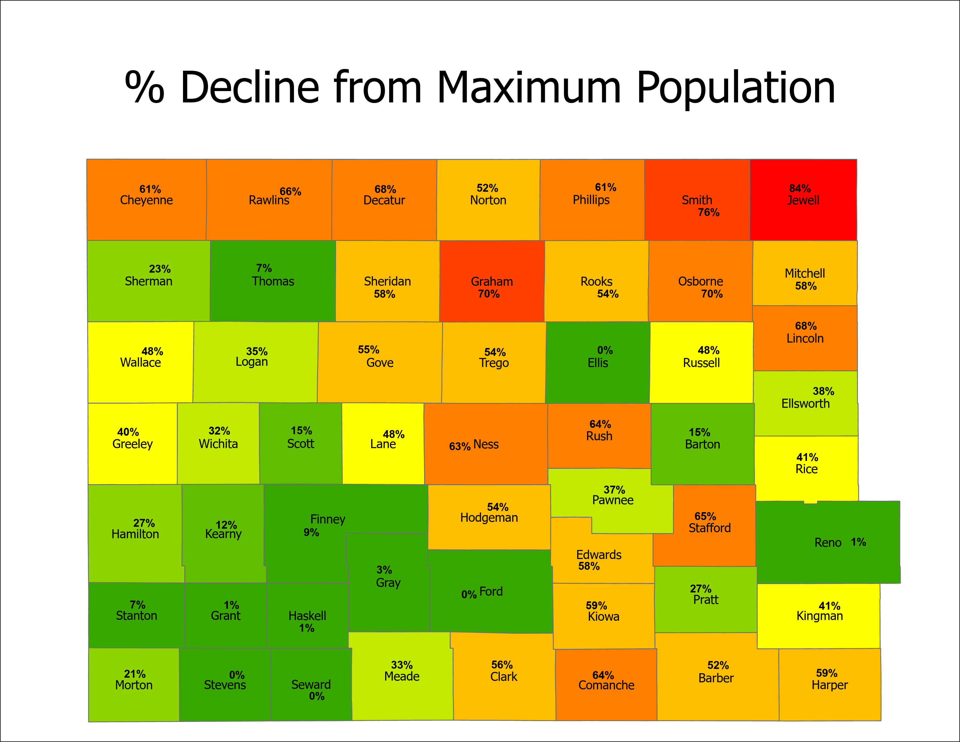
On an individual county basis, Jewell, Smith, Graham, and Osborne Counties have seen the largest overall decline in population. These counties are completely bypassed by I-70, suffered from the Dust Bowl, and suffered even more from the closure of family farms. These counties have not been able to generate the kind of tourist revenue other counties have, thanks to the fact that drivers will simply whiz right by them while driving down I-70. Two of these counties are nonfactors in petroleum production, and major railroads have closed here, which has sent them into an economic death spiral. There are many ghost towns in these counties, and many more counties that will become ghost towns. Other counties that have seen significant decline in population are Cheyenne, Rawlins, Decatur, Phillips, Rooks, Stafford, Ness, Rush, and Comanche Counties. It's very sad to see these communities shrivel up and die. There was once a time where the little towns here were bustling with opportunity, and quickly growing. But the railroads consolidating and the Dust Bowl put an end to all that, and many of these communities have never recovered. Factory farms and I-70 only hastened the process. Just knowing that these towns were once on the rise and families lived and made memories there is very sad to think about. If you are driving around in this part of the state, take some time out of your day to stop by these communities and check them out. It's only a matter of time before they're gone.